Descrizione
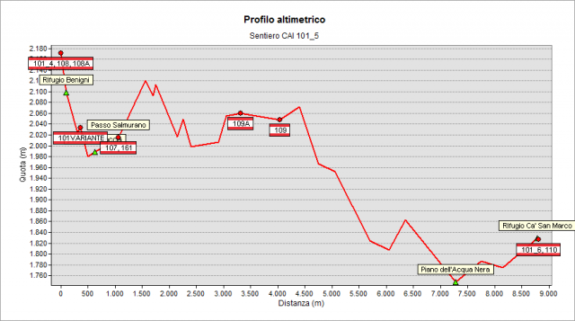
From Benigni Hut (2222 m) go down to the underlying grassy dell and to the steep rocky couloir, that you follow carefully, especially in the case of humid climate or after storms or sudden snowfalls. When you reach its base, continue along the mountainside, arriving quickly at Salmurano Pass (2017 m) from where the artificial lake of Pescegallo is clearly visible. Continue on the ridge up to a plain then turn right and - following a mountainside path - you arrive near the M. Avaro, where you cross the path n° 109. Continue until reach a fork and - passing on the opposite side - descend a dell, turn left and cross the eastern slopes of M. Ponteranica, then reach the Piano dell’Acqua Nera plain (1750 m). A last slight ascent allows you to quickly reach Ca' San Marco Hut (1829 m). Such place - which has always been used as a commercial crossing point between the Republic of Venice and the States placed north of the Alps - is a transit point of the famous “Via Priula”, a trail built between 1592 and 1593 by the will of Alvise Priuli, podestà of Bergamo. Via Priula used S. Marco Pass above to pass from the Brembana valley to the Valtellina valley, thus connecting Bergamo with Morbegno (Sondrio).
Please note
On the geoportal, the long path n° 101 has been divided into seven parts: 101_1, 101_2, 101_3, 101_4, 101_5, 101_6, and 101_7, to better describe the different stages.
However, the signage on the ground up to the Tartano Pass will report only the number 101.
Topografia

Sentieri collegati
Documentazione
Note
Al passo di Salmurano sono ancora visibili alcune trincee della "Linea Cadorna"