Descrizione
CENTRAL-EASTERN OROBIE TRAIL / SENTIERO DELLE OROBIE CENTRO-ORIENTALI
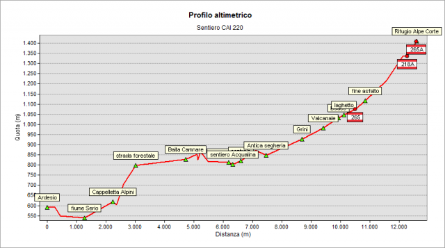
The “Sentiero delle Orobie” trail started originally from Valcanale and reached the Alpe Corte Hut after a short walk. Now, by the proposed "ring variant", you may want to start your walking in Ardesio and proceed towards the mountains gradually.
Starting near the Town Hall of Ardesio (“Pro Loco” headquarters, about 600 meters a.s.l.), the path goes down to the Serio river and cross it near the hydroelectric power plant. Then it rises for a while - following the road towards Cacciamali / Cerrete hamlets - up to reach the road that leads to the Alpini’s Chapel. After passing the chapel, there is the steepest part of the path: the trail climbs up to an altitude of about 800 m, until you reach a forest road. Now the path levels out and enters Valcanale (the valley).
After crossing the stream near Albareti, follow the didactic "Acqualina" path and pass close to a restored old sawmill.
Once reached Valcanale (the village, 987 m) follow Alpe Corte street until its end. There you can find the forest road towards the Alpe Corte Hut (1415 m).
To see all the way through Google Street View Trekker: click here
Topografia

Sentieri collegati
Documentazione
Note
The path n° 220 from Valcanale to the Alpe Corte Hut (along path n° 218 up to the passage of Branchino and path 219 up to the Mezzeno huts) is called “SENTIERO DELLE FARFALLE” (“Path of butterflies”) and presents - along the route - special bulletin boards illustrating the natural features of the area.